- Shopping, made easy.
- /
- Get the app!
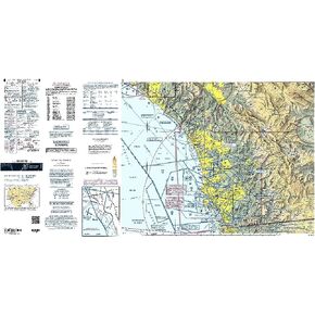
Virtually every aviator knows that flying around the nation's capital requires an incredible amount of planning and situational awareness to avoid unwanted surprises both in the air and on the ground. To help keep area pilots on good terms with Uncle Sam, the general public, and commercial carriers who operate in the area, the FAA's Baltimore - Washington Terminal Area Chart (TAC) should be a "no-go" item that's front and center from takeoff to touchdown during operations around the area's bustling Class B airspace complex.Like all charts in the TAC lineup, the Baltimore - Washington Terminal Chart utilizes a larger (1:250,000; 3.43 nm per inch [1.35 nm per cm]) scale than FAA Sectional Charts that allows it to portray additional landmarks, important altitudes, radio frequencies, and other noteworthy aviation info that's not feasible to include on sectionals. Additionally, this chart highlights many of the complexities and vital operating procedures pilots must follow to remain in compliance with the rules of the region's Special Flight Rules Area (SFRA). As with all TAC publications, this chart is revised every six months. A low-cost, info-packed resource that no Mid-Atlantic area pilot should ever risk flying without.