- Shopping, made easy.
- /
- Get the app!
Printed area: 34 x 39 inches. Printed directly on canvas and rolled for shipping. There is approximately 5" of unprinted border to allow for stretching the canvas print onto a frame. Ideal for large and decorative maps.
This map shows North America at a scale of 1: 10 000 000. The map is a general reference map giving detailed coverage of populated places, transportation routes and the drainage network. Land areas are colored to represent individual countries and dependencies. The map sheet has three inset maps showing the Aleutian Islands (Alaska), Hawaii and the North America relief with significant mountain elevations. There is also a table of road mileages between major cities.
Scale 1:10,000,000
 -7%
Carson Dellosa | Blank Books for Journaling | High-Gloss Cover, 7-inch x 10-inch, 12-Pack
KWD 6.500
-7%
Carson Dellosa | Blank Books for Journaling | High-Gloss Cover, 7-inch x 10-inch, 12-Pack
KWD 6.500
 -4%
4 Pack Teacher Appreciation Gifts, Teacher Gifts from Student, Teacher Appreciation Week Gifts, 20 oz Skinny Teacher Tumbler for Teacher Week, Birthday, Back to School, Christmas
KWD 11.500
-4%
4 Pack Teacher Appreciation Gifts, Teacher Gifts from Student, Teacher Appreciation Week Gifts, 20 oz Skinny Teacher Tumbler for Teacher Week, Birthday, Back to School, Christmas
KWD 11.500
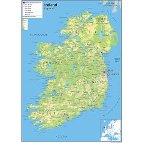 Ireland Physical Poster Map - 16.5 x 23.3 inches - Paper Laminated
KWD 10.500
Ireland Physical Poster Map - 16.5 x 23.3 inches - Paper Laminated
KWD 10.500
 Teacher Created Resources Travel the Map Computer Paper, 8.5" x 11", 50 Sheets
KWD 5
Teacher Created Resources Travel the Map Computer Paper, 8.5" x 11", 50 Sheets
KWD 5


