South Carolina is a southeastern U.S. state known for its shoreline of subtropical beaches and marshlike sea islands. Coastal Charleston is a historic city, defined by pastel-colored houses, Old South plantations and Fort Sumter, where the Civil War's opening shots were fired. To the north is the Grand Strand, a roughly 60-mile stretch of beachfront known for golf courses and the vacation town Myrtle Beach.
Our South Carolina State Map showcases its geography, with easy-to-read text, and features like capital cities, rivers, major roads, towns, and bodies of water. It's perfect for any room, office, or school, and a great way to gain a comprehensive view of the state.country.
Size - 23.4 x 15.4 Inches.
Printed onto a high quality paper and laminated for durability.
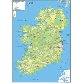 Ireland Physical Poster Map - 16.5 x 23.3 inches - Paper Laminated
KWD 10.500
Ireland Physical Poster Map - 16.5 x 23.3 inches - Paper Laminated
KWD 10.500
 United Kingdom of Great Britain and Northern Ireland Poster Map - 16.5 x 23.3 inches - Paper Laminated
KWD 11
United Kingdom of Great Britain and Northern Ireland Poster Map - 16.5 x 23.3 inches - Paper Laminated
KWD 11
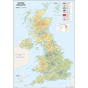
 Physical United Kingdom Poster Map - 16.5 x 23.3 inches - Paper Laminated
KWD 10.500
Physical United Kingdom Poster Map - 16.5 x 23.3 inches - Paper Laminated
KWD 10.500
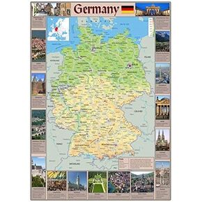 Pictorial Poster Map of Germany - 23.4 x 16.5 inches - Paper Laminated
KWD 10.500
Pictorial Poster Map of Germany - 23.4 x 16.5 inches - Paper Laminated
KWD 10.500


