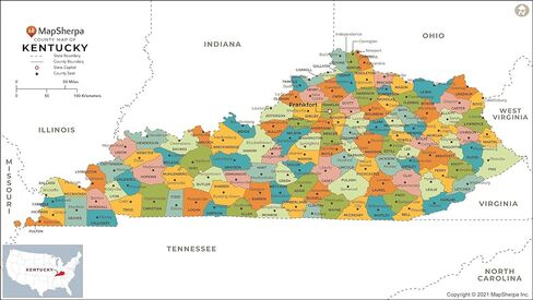
THE BLUEGRASS STATE: The map shows the 120 counties of Kentucky and their borders.
CREATED EXCLUSIVELY: Map has been created for MapSherpa, and designed for business or reference use.
CLEAR AND CLEAN: Map colors and fonts have been designed for maximum usability & readability. As well as expertly researched by cartographers to ensure accuracy.
36 x 20.25 inches. Laminated. Flat map, tubed for shipping.
Description
36 x 20.25 inches. Laminated. Flat map, tubed for shipping.
This map has been created exclusively for MapSherpa, and designed for reference or business use. Clear and clean colors & fonts matched with cartographic research makes this map of Kentucky Counties Map easily readable and useful. The map shows the 120 counties of Kentucky and their borders across the Bluegrass State.