Discover Illinois, Indiana, Ohio, and Kentucky with this stunning physical map, boasting remarkable insights on capital cities, size, population, and largest cities, plus airports, highways, boundaries, and population centers. Illinois is a Midwestern state, renowned for its two biggest cities, Chicago and its Metro East section of Greater St. Louis. Additional spots like Peoria and Rockford, as well as Springfield, the state's capital, join in the mix.
Boasting the fifth-largest GDP and the sixth-largest population of the fifty U.S. states, and a 25th-largest land area, Illinois is sure to delight! Indiana, rooted in the Midwest, is the 38th-largest by area and holds the 17th-largest population of all 50 states, with its capital of Indianapolis taking the fore. Ohio, the seventh-most populous state in the US, overflows with over 11.8 million residents across 34,000 square miles.
Home to bustling cities such as Columbus, Cleveland, Cincinnati, Dayton, Akron and Toledo, it's no wonder Ohio is a hub of activity. Kentucky—the "Bluegrass State"—boasts a population of approximately 4.5 million, with its capital city Frankfort and largest city Louisville.
Outlining the physical features of each state in vivid detail, this map makes it easier for you to identify and explore the surrounding region. From the great economic features of Illinois, the history of Indiana, the vibrant culture of Ohio, and the Bluegrass State of Kentucky, you'll find the perfect starting point for your next big adventure.
Size - 23.3 x 16.5 Inches
Printed onto a high quality paper and laminated for durability.
 Pictorial Poster Map of Ireland - 23.4 x 16.5 inches - Paper Laminated
KWD 10.500
Pictorial Poster Map of Ireland - 23.4 x 16.5 inches - Paper Laminated
KWD 10.500
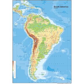 South America Physical Poster Map - 23.3 x 16.5 Inches - Paper Laminated
KWD 10.500
South America Physical Poster Map - 23.3 x 16.5 Inches - Paper Laminated
KWD 10.500
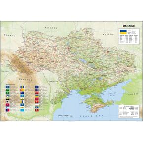 Ukraine Physical Poster Map - 23.3 x 33.1 Inches - Paper Laminated
KWD 14
Ukraine Physical Poster Map - 23.3 x 33.1 Inches - Paper Laminated
KWD 14
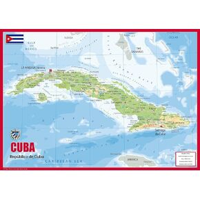 Cuba Physical Poster Map - 23.3 x 16.5 Inches - Paper Laminated
KWD 10.500
Cuba Physical Poster Map - 23.3 x 16.5 Inches - Paper Laminated
KWD 10.500


