- Shopping, made easy.
- /
- Get the app!

Each map has two sides. Side 1 includes: A colorful map of Oregon that includes all the major cities A map legend that includes where all the major industries are located throughout the state Origin of Oregon's name History of Oregon's flag and image of the flag Oregon's statehood date Oregon state seal Side 2 includes: A black & white image of all of the counties in Oregon Each map is 8.5'' X 11'' and printed glossy paper.

 Jetec 300 Pcs Scratch and Sniff Sticker for Kids Smelly Scented Motivational Stickers Reward Teacher Incentive Positive Decorations for Student Classroom Chart School Supplies
KWD 4.500
Jetec 300 Pcs Scratch and Sniff Sticker for Kids Smelly Scented Motivational Stickers Reward Teacher Incentive Positive Decorations for Student Classroom Chart School Supplies
KWD 4.500
 Marsui 8 Pcs Floor Cushions for Classroom Kids Flexible Floor Seating Flexible Seating Classroom 3.2 Inch Thickened Foam Circle Seats Round Floor Seating for School Kindergarten Home Chair
KWD 31
Marsui 8 Pcs Floor Cushions for Classroom Kids Flexible Floor Seating Flexible Seating Classroom 3.2 Inch Thickened Foam Circle Seats Round Floor Seating for School Kindergarten Home Chair
KWD 31
 -20%
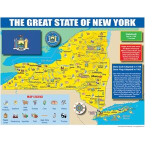
Publishing Group New York State Map for Students - Pack of 30 (9780635106599)
KWD 6
-20%
Publishing Group New York State Map for Students - Pack of 30 (9780635106599)
KWD 6
 Trends International Netflix Stranger Things: Season 4 - Map Wall Poster, 22.375" x 34", Poster & Mount Bundle
KWD 4.500
Trends International Netflix Stranger Things: Season 4 - Map Wall Poster, 22.375" x 34", Poster & Mount Bundle
KWD 4.500
