- Shopping, made easy.
- /
- Get the app!

Each map has two sides. Side 1 includes: A colorful map of Kansas that includes all the major cities A map legend that includes where all the major industries are located throughout the state Origin of Kansas's name History of Kansas's flag and image of the flag Kansas's statehood date Kansas state seal Side 2 includes: A black & white image of all of the counties in Kansas Each map is 8.5'' X 11'' and printed glossy paper.

 -13%
Teacher Created Resources Confetti Magnetic Hall Pass
KWD 3.500
-13%
Teacher Created Resources Confetti Magnetic Hall Pass
KWD 3.500
 -20%
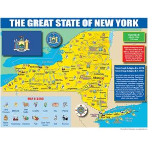
Publishing Group New York State Map for Students - Pack of 30 (9780635106599)
KWD 6
-20%
Publishing Group New York State Map for Students - Pack of 30 (9780635106599)
KWD 6
 The Complete Common Core State Standards Kit for Language Arts, Grade 7
KWD 4.500
The Complete Common Core State Standards Kit for Language Arts, Grade 7
KWD 4.500
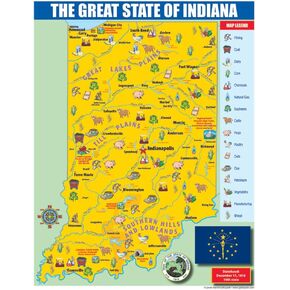 Gallopade Publishing Group Indiana State Map for Students - Pack of 30 (9780635106414)
KWD 6
Gallopade Publishing Group Indiana State Map for Students - Pack of 30 (9780635106414)
KWD 6
