- Shopping, made easy.
- /
- Get the app!
Map Size: 16"x19". Discover the power of maps as a learning tool with Black History Africa Slave Maps. Maps are a powerful way to learn about history, genealogy, and geography. These maps can be used by students for school projects, teachers for lesson plans, or anyone who is interested in African American history. These maps feature all the countries that were affected by European colonialism and slavery. They show how these countries were reshaped by European colonialism and slavery. Maps are also excellent wall art and can enhance any decorating style. Transform a classroom, school, office, kitchen, bath, living room, game room, or bedroom with these maps.

 12" Plastic Folded Rulers Assorted Color 5pcs Pack, Foldable, Portable, Easy to Carry, Durable Printing in Inch and Metric Scale, Pefect Measuring and Drawing Tools
KWD 4.500
12" Plastic Folded Rulers Assorted Color 5pcs Pack, Foldable, Portable, Easy to Carry, Durable Printing in Inch and Metric Scale, Pefect Measuring and Drawing Tools
KWD 4.500
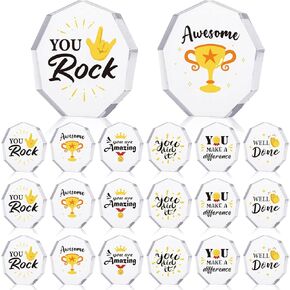 Janmercy 24 Pcs Appreciation Acrylic Award Trophies 6 Styles Employee Appreciation Gifts Bulk Plaques Personalized Engraved Fun Clear Cna Thank You Gift for Adults Office Party Decoration(Medal)
KWD 10.500
Janmercy 24 Pcs Appreciation Acrylic Award Trophies 6 Styles Employee Appreciation Gifts Bulk Plaques Personalized Engraved Fun Clear Cna Thank You Gift for Adults Office Party Decoration(Medal)
KWD 10.500
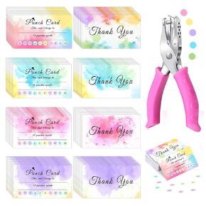 200 Pieces Reward Punch Cards with Hole Puncher, Incentive Loyalty Reward Card Circle Handheld Punch Kit, Kids Behavior Incentive Awards Cards for Business Classroom School Supplies(3.5" x 2")
KWD 4.500
200 Pieces Reward Punch Cards with Hole Puncher, Incentive Loyalty Reward Card Circle Handheld Punch Kit, Kids Behavior Incentive Awards Cards for Business Classroom School Supplies(3.5" x 2")
KWD 4.500
 -17%
30Pcs Anxiety Relief Acupressure Rings, Sensory Finger Rings for Teens Adults Fidget Rings Silent Stress Reducer Rings for OCD ADHD Autism
KWD 2.500
-17%
30Pcs Anxiety Relief Acupressure Rings, Sensory Finger Rings for Teens Adults Fidget Rings Silent Stress Reducer Rings for OCD ADHD Autism
KWD 2.500


