- Shopping, made easy.
- /
- Get the app!

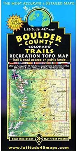
Boulder County Recreation Topographic Map is an outdoor recreation topographic map for the Boulder County, Colorado area published by Latitude 40 Maps.
Map Coverage – covers all or part of 22 USGS 1:24,000 7.5-minute quad maps North – Grand Lake – Longs Peak – Pinewood Springs – Rabbit Mountain Open Space
South – Mary Jane Ski Area – Rogers Pass – Broomfield
East – Longmont – Lafayette – Broomfield
West – Grand Lake – Fraser – Winter Park
Size Unfolded – 39.3″ × 25.2″
Folded – 8″ × 4″
Scale 1:75,000
1 inch = 1.2 miles or 1.9 km
Contour Interval – 80 feet with shaded relief base
Latest Edition – 3rd – June 10, 2012
Back Side cool 3-D Computer-generated relief map
40 trails descriptions with elevation/distance profiles
Notes Indian Peaks Wilderness
southern Rocky Mountain National Park
James Peak Wilderness
Boulder Mountain Parks and Open Space
Nederland area trails
Roosevelt National Forest
color-coded elevation tinting
hundreds of miles of GPS-surveyed travel routes
GPS mileage between junctions
latitude and longitude map borders with UTM coordinates
 Sangre de Cristo Wilderness NORTH - Colorado Topographic Hiking Map (2022)
KWD 4
Sangre de Cristo Wilderness NORTH - Colorado Topographic Hiking Map (2022)
KWD 4
 Outdoor Trail Maps LLC Eagles Nest Wilderness - Colorado Topographic Hiking Map (2018)
KWD 4
Outdoor Trail Maps LLC Eagles Nest Wilderness - Colorado Topographic Hiking Map (2018)
KWD 4
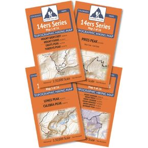 Outdoor Trail Maps Colorado 14ers Series Front-Tenmile-Mosquito Range Map Pack
KWD 9.500
Outdoor Trail Maps Colorado 14ers Series Front-Tenmile-Mosquito Range Map Pack
KWD 9.500
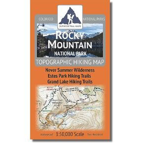 Rocky Mountain National Park - 2021 Topographic Hiking Map
KWD 4.500
Rocky Mountain National Park - 2021 Topographic Hiking Map
KWD 4.500