- Shopping, made easy.
- /
- Get the app!
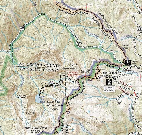
Waterproof, tear-resistant topographic hiking map covering all of the hiking trails in the South San Juan Wilderness of southern Colorado, including the southeastern portion of the San Juan Mountains. The front side of the map covers the northern portion of the wilderness just south of Wolf Creek Pass and west of Pagosa Springs, CO. The back of the map shows the southern part of the South San Juan Wilderness, including a large part of the Rio Grande National Forest. This map shows the southern part of Colorado's continental divide including the continental divide national scenic trail.
 Sangre de Cristo Wilderness NORTH - Colorado Topographic Hiking Map (2022)
KWD 4
Sangre de Cristo Wilderness NORTH - Colorado Topographic Hiking Map (2022)
KWD 4
 Rawah Wilderness - Colorado Topographic Hiking Map (2018)
KWD 4
Rawah Wilderness - Colorado Topographic Hiking Map (2018)
KWD 4
 Lizard Head - Mount Sneffels Wilderness - Colorado Topographic Hiking Map (2018)
KWD 4
Lizard Head - Mount Sneffels Wilderness - Colorado Topographic Hiking Map (2018)
KWD 4
 Outdoor Trail Maps LLC Eagles Nest Wilderness - Colorado Topographic Hiking Map (2018)
KWD 4
Outdoor Trail Maps LLC Eagles Nest Wilderness - Colorado Topographic Hiking Map (2018)
KWD 4