- Shopping, made easy.
- /
- Get the app!
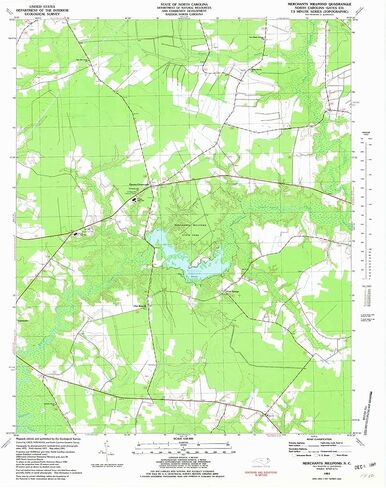
USGS topographic map of Merchants Millpond, North Carolina, dated 1981, updated 1981.
Includes geographic coordinates (latitude and longitude), lines of elevation, bodies of water, roads, and more. This topo quad is suitable for recreational, outdoor uses, office applications, or wall map framing.
Printed on-demand by YellowMaps on the print material of your choice.
Shipping rolled from Minneapolis, MN, United States.
Product Number: USGS-5371926
Map Size: 26.9 inches high x 21.9 inches wide
Map Scale: 1:24000
Map Type: POD USGS Topographic Map
Map Series: HTMC
Map Version: Historical
Cell ID: 28821
Scan ID: 163464
Imprint Year: 1981
Woodland Tint: Yes
Aerial Photo Year: 1975
Edit Year: 1981
Field Check Year: 1977
Datum: NAD27
Map Projection: Lambert Conformal Conic
Map published by United States Geological Survey
Map Language: English
Scanner Resolution: 600 dpi
Map Cell Name: Merchants Millpond
Grid size: 7.5 X 7.5 Minute
Date on map: 1981
Geographical region: North Carolina, United States
Northern map edge Latitude: 36.5°
Southern map edge Latitude: 36.375°
Western map edge Longitude: -76.75°
Eastern map edge Longitude: -76.625°
Surrounding map sheets (copy & paste the Product No. in the search bar):
North: USGS-5301916,USGS-5303462,USGS-5303468,USGS-5301918,USGS-5303460
East: USGS-5373622,USGS-5373620
South: USGS-5372014,USGS-5372016
West: USGS-5370598,USGS-5370600,USGS-5370602
 YellowMaps Clanton East AL topo map, 1:24000 Scale, 7.5 X 7.5 Minute, Historical, 1972, Updated 1984, 26.7 x 21.9 in
KWD 12.500
YellowMaps Clanton East AL topo map, 1:24000 Scale, 7.5 X 7.5 Minute, Historical, 1972, Updated 1984, 26.7 x 21.9 in
KWD 12.500
 Lizard Head - Mount Sneffels Wilderness - Colorado Topographic Hiking Map (2018)
KWD 4
Lizard Head - Mount Sneffels Wilderness - Colorado Topographic Hiking Map (2018)
KWD 4
 Beartooth Publishing Wind River Range South, Wyoming Topographic Shaded Relief Outdoor Recreation Map
KWD 8
Beartooth Publishing Wind River Range South, Wyoming Topographic Shaded Relief Outdoor Recreation Map
KWD 8
 Outdoor Trail Maps LLC Hunter-Fryingpan/Mount Massive Wilderness - Colorado Topographic Hiking Map (2018)
KWD 4
Outdoor Trail Maps LLC Hunter-Fryingpan/Mount Massive Wilderness - Colorado Topographic Hiking Map (2018)
KWD 4