- Shopping, made easy.
- /
- Get the app!
Indiana is a state in the Midwestern region of the United States. It borders Lake Michigan to the northwest, Michigan to the north and northeast, Ohio to the east, the Ohio River and Kentucky to the south and southeast, and the Wabash River and Illinois to the west. This physical map of Indiana presents key information such as the capital cities, population, area size, and largest city, plus locations of airports, major highways, state boundaries, and populated areas. In addition, the map includes bodies of water and points of interest such as national and state parks, forests, cultural sites, and more.
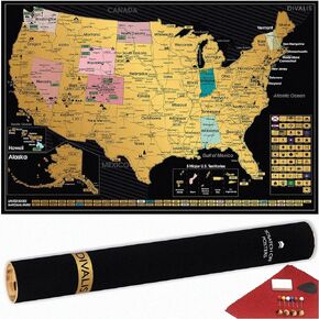 Detailed Scratch off USA Map with Scratcher - 24x16 Easy to Frame 63 National Parks Scratch Off Travel Poster of the United States of America - Large Scratchable US Map with Landmarks and States Flags
KWD 10.500
Detailed Scratch off USA Map with Scratcher - 24x16 Easy to Frame 63 National Parks Scratch Off Travel Poster of the United States of America - Large Scratchable US Map with Landmarks and States Flags
KWD 10.500
 120 Pieces Reward Punch Cards Incentive Loyalty Awards Card for Classroom, Business, Kids, Students, Teachers…
KWD 2.500
120 Pieces Reward Punch Cards Incentive Loyalty Awards Card for Classroom, Business, Kids, Students, Teachers…
KWD 2.500
 10 Year Out of The Ashes of Addiction Medallion Phoenix in Flames Chip
KWD 6
10 Year Out of The Ashes of Addiction Medallion Phoenix in Flames Chip
KWD 6
 Praying Hands Serenity Prayer 33mm Key Chain Tag Keychain Keytag Bronze AA Alcoholics Anonymous NA Recovery Sobriety Gift
KWD 3
Praying Hands Serenity Prayer 33mm Key Chain Tag Keychain Keytag Bronze AA Alcoholics Anonymous NA Recovery Sobriety Gift
KWD 3


