- Shopping, made easy.
- /
- Get the app!

Map: Pannonia. /Nengraved Map, 19Th Century, Depicting The Ancient Areas Of Pannonia, Moesia, Dacia, And Illyricum. is a licensed reproduction that was printed on Premium Heavy Stock Paper which captures all of the vivid colors and details of the original. The overall paper size is 24.00 x 36.00 inches. This print is ready for hanging or framing and would make a great addition to your home or office decor.

 -7%
Seat Sack Elastic Back Storage Pocket, 12 to 17 Inches, Blue
KWD 6.500
-7%
Seat Sack Elastic Back Storage Pocket, 12 to 17 Inches, Blue
KWD 6.500
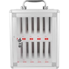 -9%
TOYANDONA 12 Slots Aluminum Alloy Pocket Chart Cell Phones Storage Cabinet Wall- Mounted with Lock and Handle Pocket Chart Storage Locker Box for Cell Phones Office Classroom
KWD 15
-9%
TOYANDONA 12 Slots Aluminum Alloy Pocket Chart Cell Phones Storage Cabinet Wall- Mounted with Lock and Handle Pocket Chart Storage Locker Box for Cell Phones Office Classroom
KWD 15
 World Map Catalan Atlas 1375 Poster Print by Science Source (36 x 24)
KWD 24
World Map Catalan Atlas 1375 Poster Print by Science Source (36 x 24)
KWD 24
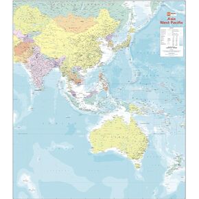 -18%
Asia West Pacific Political Wall Map - 39.5" x 34.5" Laminated
KWD 15.500
-18%
Asia West Pacific Political Wall Map - 39.5" x 34.5" Laminated
KWD 15.500
