- Shopping, made easy.
- /
- Get the app!
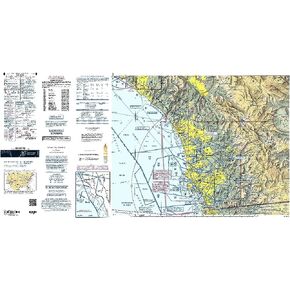
Those who fly near the US/Canada border and in the remote, rugged regions of Montana and Idaho realize the importance of a reliable source of aeronautical navigation data to help keep them safe and informed during their operations in such unforgiving environments. Fortunately, the FAA's Great Falls Sectional Chart provides all the need-to-know aviation info to help them maintain their situational awareness from takeoff to touchdown. As with all charts in the FAA's Sectional series, this foldable, full-color chart is loaded with valuable aviation data including airport info (runway lengths, lighting, elevation, services available, surface type, etc.); airspace dimensions; VHF and LF/MF navigational facilities (frequency, ID, and channel); landmarks; cities & towns; elevation/topographic info; ATC entities and associated contact/radio frequencies; bodies of water; obstructions; and much, much more.The Great Falls Sectional covers the airspace over Western Montana and Northern Idaho, including the US/Canada border region. Uses the standard 1:500,000 (6.86 nm per inch; 2.70 nm per cm) scale characteristic of sectional charts. Updated every six months. A low-cost, info-packed source of relevant FAA data to help you enjoy the wild blue yonder in Big Sky Country.