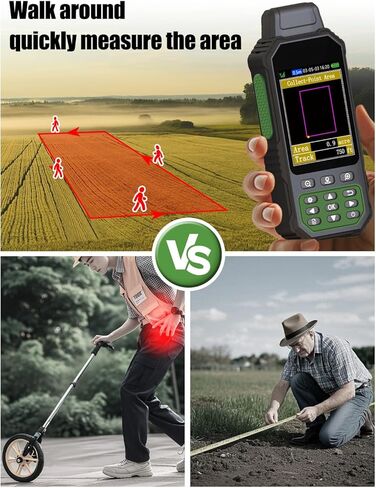
ZL190PLUS Handheld GPS for Surveying, High Precision Land Surveying Equipment, Land Surveyors Tools, Handheld Land Measuring tool for Forest Farmland Mountain Mining Lake
All electronics ship with US style plugs.You may need a voltage converter or a plug adapter.
Special Features
HIGH PRECISION ACCURACY: Great support 4 navigation satellite system,GPS+BEIDOU+GLONASS+QZSS ,strong satellite signal,area measurement error in 0.002 acres
3.2'' LARGE SCREEN: Equipped with TFT backlight display, the measurement results can be displayed on the screen clearly, convenient for observation
5 IN 1 MEASUREMENT: The area of any terrain (gardens, parking lots, pastures and flat lands) can be measured, curve line distance and slope can be measured
DURABLE DESIGN: IP67 waterproof strong dust-proof function.Portable design, fits in your hand or pockets perfectly, equipped wrist strap lets you hold the meter steady and carry
WHAT YOU GET: 1x GPS Surveying Equipment, 1x User Manual, 1x Charge Cable, 1x Hand Strap. 2 year manufacture.Please be sure to read the User Manual carefully before operating


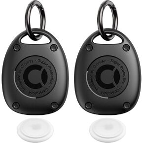
 ColorCoral 2 Pack AirTag Holder with Keychain Shockproof Protective Cover for Apple AirTag Durable Anti-Scratch Air Tag Case Silicone Sleeve for AirTag Accessories Tracker Cover
KWD 3
ColorCoral 2 Pack AirTag Holder with Keychain Shockproof Protective Cover for Apple AirTag Durable Anti-Scratch Air Tag Case Silicone Sleeve for AirTag Accessories Tracker Cover
KWD 3
 Garmin Approach S12, Easy-to-Use GPS Golf Watch, 42k+ Preloaded Courses, White, 010-02472-02
KWD 73
Garmin Approach S12, Easy-to-Use GPS Golf Watch, 42k+ Preloaded Courses, White, 010-02472-02
KWD 73
 (2 Pack) AirTag Keychain Holder Case | IPX8 Waterproof, Ultra-Compact | Portable Air Tag Holder Cover for Dog Collar, Backpack, Keys, Luggage - Black
KWD 5
(2 Pack) AirTag Keychain Holder Case | IPX8 Waterproof, Ultra-Compact | Portable Air Tag Holder Cover for Dog Collar, Backpack, Keys, Luggage - Black
KWD 5
 MiLi 2 Pack Bluetooth Tracker Tag for iOS, Mitag Items Finder Locator Compatible with Apple Find My Luggage Tracker, IP67 Waterproof Tracker for Dog, Key, Luggage, Suitcase, Bag, Wallet
KWD 7
MiLi 2 Pack Bluetooth Tracker Tag for iOS, Mitag Items Finder Locator Compatible with Apple Find My Luggage Tracker, IP67 Waterproof Tracker for Dog, Key, Luggage, Suitcase, Bag, Wallet
KWD 7