All electronics ship with US style plugs.You may need a voltage converter or a plug adapter.
Special Features
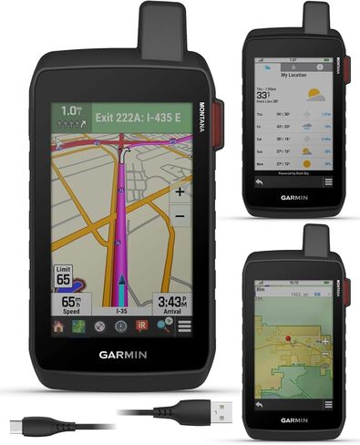
IN THE BOX: Garmin Montana 760i, Li-ion battery pack, USB cable, Wearable4U PowerBank, Documentation.
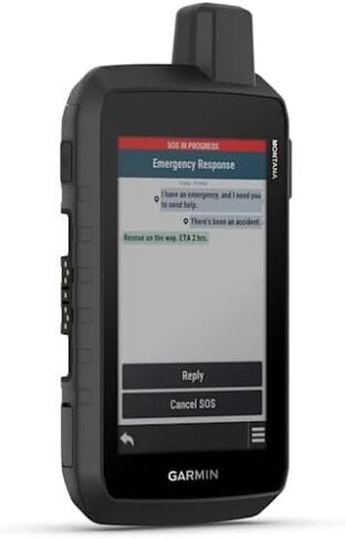
Stay Connected Beyond Cell Service. The 5” rugged handheld GPS navigator incorporates inReach satellite communication, ensuring connectivity even in areas without cell service. With an active subscription, it provides two-way text messaging, global location tracking via the Iridium satellite network, and interactive SOS capabilities. Users can confidently explore remote locations while remaining in contact with loved ones or emergency services.
Emergency Response and Safety. The device connects to the Garmin ResponseSM team, an international 24/7-staffed emergency coordination center, allowing users to send SOS alerts. This feature is invaluable for adventurers in remote regions where traditional communication options are unavailable. Note that regulations on satellite communication devices vary by jurisdiction.
Integrated Camera for Navigation. The built-in 8-megapixel autofocus camera allows users to capture photos and tag their locations. This feature enhances navigation by enabling adventurers to revisit specific sites. It's a practical addition for outdoor enthusiasts who document their travels and rely on visual references for route planning.
Durable and User-Friendly Design. The GPS navigator boasts a 5” glove-friendly color touchscreen for easy viewing. Its rugged design meets MIL-STD 810 standards for thermal, shock, and vibration resistance, as well as an IPX7 water-resistance rating. Versatile mounting options (sold separately) enhance its usability across various activities.
Comprehensive Mapping and Navigation. Preloaded with TopoActive maps and City Navigator maps, the device supports on-road and off-road navigation. Users can download additional maps like BlueChart g3 charts for water exploration. High-resolution satellite imagery offers photorealistic overhead views, enabling waypoint creation based on landmarks.
Ample Storage and Premium Content. With 32 GB of expanded memory, users can store additional maps and data. A subscription to Outdoor Maps+ provides ongoing access to premium mapping content, downloadable via Wi-Fi. This ensures users always have updated resources for their expeditions.
Enhanced Navigation and Weather Forecasts. Built-in ABC sensors (altimeter, barometer, and compass) aid navigation and monitor environmental conditions. Users can access active weather updates through the Garmin Connect app or inReach weather forecast services, keeping them informed about potential weather changes during their adventures.
Extended Battery Life and Charging Convenience. The rechargeable lithium-ion battery delivers up to 24 hours of life in GPS mode and an impressive 432 hours in expedition mode. The device supports USB-C charging for convenience, ensuring it remains ready for long-duration trips without frequent recharging.
Advanced Satellite Support and Connectivity. Multi-GNSS support (GPS and Galileo) ensures reliable navigation in challenging environments. Compatibility with the Garmin Explore app enables users to manage waypoints, routes, and activities while reviewing trip data. The live tracking page lets followers monitor progress and communicate during trips, enhancing safety and connectivity.


 Wearable4U - Garmin Montana 700 Rugged GPS Touchscreen Navigator with Included Ultimate E-Bank Bundle
KWD 209
Wearable4U - Garmin Montana 700 Rugged GPS Touchscreen Navigator with Included Ultimate E-Bank Bundle
KWD 209
 Wearable4U - Garmin RV 795 GPS Navigator, Large, Easy-to-Read 7, Custom RV Routing, High-Resolution Birdseye Satellite Imagery with Power Pack Bundle
KWD 167.500
Wearable4U - Garmin RV 795 GPS Navigator, Large, Easy-to-Read 7, Custom RV Routing, High-Resolution Birdseye Satellite Imagery with Power Pack Bundle
KWD 167.500
 Wearable4U - Bushnell iON Elite Black Golf GPS Watch with Lens Cleaning Cloth Bundle
KWD 75
Wearable4U - Bushnell iON Elite Black Golf GPS Watch with Lens Cleaning Cloth Bundle
KWD 75
 Wearable4U - Garmin Approach S12 Premium GPS Golf Watch, Black and All-in-One Golf Tools Bundle
KWD 76.500
Wearable4U - Garmin Approach S12 Premium GPS Golf Watch, Black and All-in-One Golf Tools Bundle
KWD 76.500