Search

The Times Atlas: The Great Lakes (United States) - Compact - 22.25 x 16.25 inch Poster - Front Lamination

KWD 9.500

1 +

Special Features

  • TRUSTED PUBLISHER: The Times are a world leader in the publishing industry and are one of the most recognizable brands around the globe. This map is taken from The Times Comprehensive Atlas of the World, which is regarded as the world's most prestigious and authoritative source of atlases and maps.
  • STYLISH CARTOGRAPHY: These beautiful natural colors help to highlight the physical features, making this perfect a perfect look for the classroom, home or boardroom.
  • MAJOR FEATURES: Map details include detailed road and highway networks, international borders, water depth, distance above/below sea level, and more!
  • HIGH QUALITY PRINT: Your laminated map has a glossy finish so that you can use dry erase markers on the map to highlight features, make plans, and share unique information with others. Lamination is also extremely durable, resistant to folding or ripping. Your map is rolled and packaged in a sturdy tube to protect it during shipment.
  • ROLLED IN A STURDY TUBE: Your map is rolled and packaged in a sturdy tube to protect it during shipment

Description

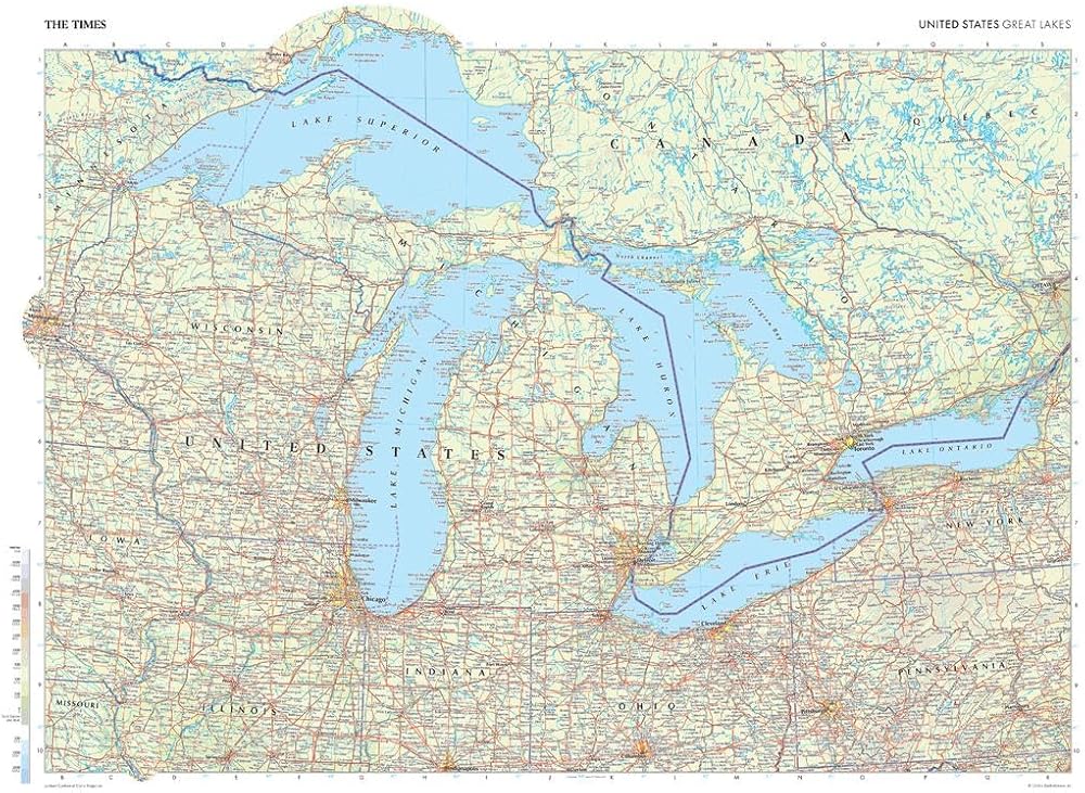
This map of the US Great Lakes region stands as a benchmark of cartographic excellence, sourced from the industry-leading Times Comprehensive Atlas of the World. Published in full colour, this map offers a comprehensive and updated view of the landscapes found in this area. Encompassing states such as Michigan, Wisconsin, Ohio, and more, this map includes many of the majestic Great Lakes: Michigan, Superior, Erie, Ontario, and Huron. With meticulous attention to detail, this map is an indispensable guide to the geographic intricacies of the US Great Lakes region. Page Size: 22.25 x 16.25 in (561 x 410 mm)

Your laminated map has a glossy finish so that you can use dry erase markers on the map to highlight features, make plans, and share unique information with others. Lamination is also extremely durable, resistant to folding or ripping. Your map is rolled and packaged in a sturdy tube to protect it during shipment.

Related Items


{"error":"Error","cart_limit":"You have too many items in your cart.","prod_limit":"You cannot add any more of this item"}